Last week my son and I headed out to explore a bit of the Gordon River watershed. The river starts close to Cowichan lake but flows southwest to Port Renfrew and the Pacific. We headed out from home to Port Renfrew then made our way “upstream”. This is the first bridge across the river, near Port Renfrew. Yes, the water was clear and this colour.


We headed on, exploring various logging spurs to see if we could find a camping spot that had a view, and had some snow. The problem we encountered was that when we found snow on those spurs, it was heavy corn snow, got deepish quickly (20 – 30 cm) and with the steep grades we really couldn’t make much headway.

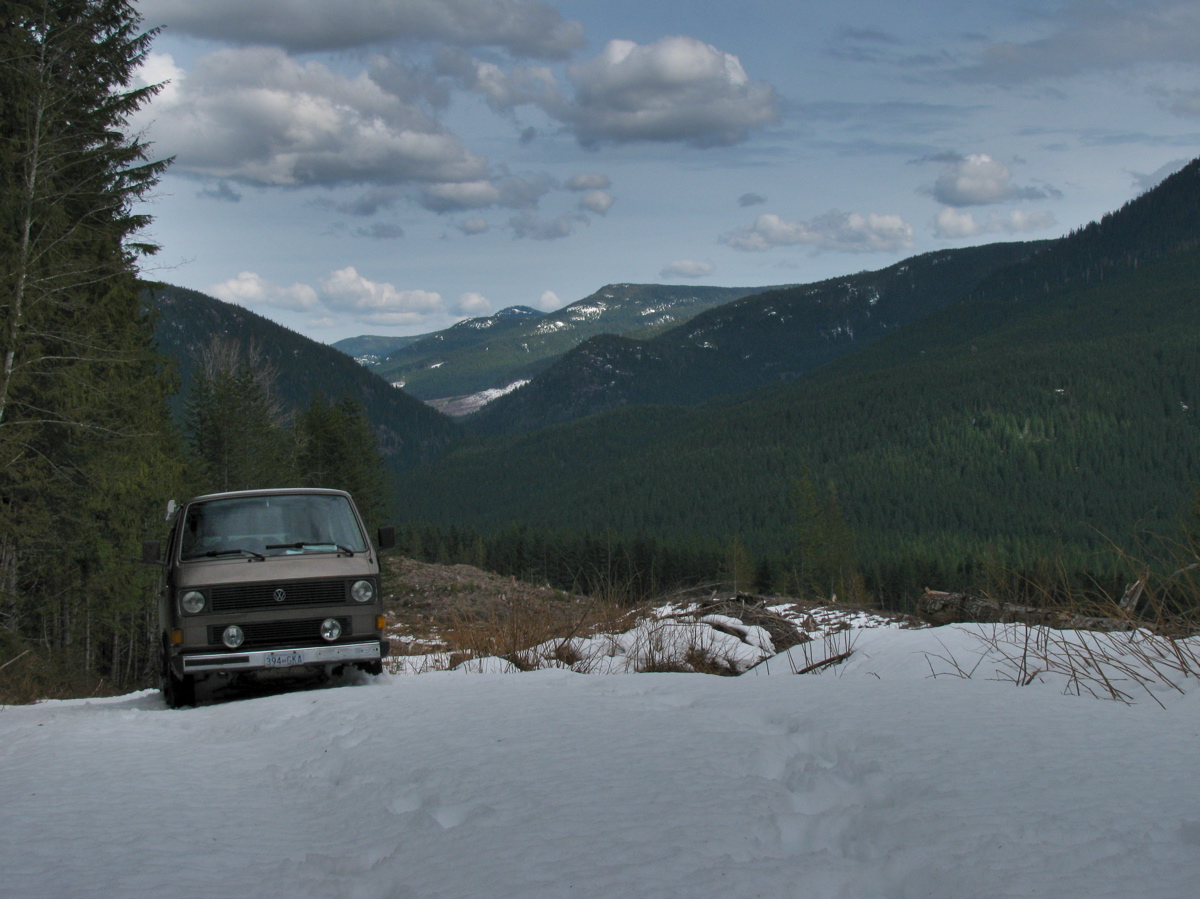
We ended up at a spot in a recently logged area, about 50 meters below where the snow started.


Well, we had a bit of a view and no shortage of table material.

A word about logging in this valley. I’m guessing most of the watershed, was logged by the middle of the last century. It would have been mostly Douglas Fir and Western Red Cedar, big trees. Now what you see is second growth, Doug Fir, Hemlock, some small cedars. The biggest stumps I saw were about 60 cm diameter. That section in above picture had around 50-60 growth rings. Here are some pic of the recently logged area, showing some old grey stumps from the first cut.


Next day we headed on, again being foiled by steep snow covered spurs, and we decided to try to get to the trail head for Mount Sutton. We found the access road on the north side of the river to be choked with alders. This road starts at the site of the old Gordon River logging camp, which at its peak (1950?) was one of the biggest camps on the island (google map ref). Pretty well nothing remains of the camp now, but if you dig around this site you can find some info and pictures of how it used to be. One strange relic remains, a Mk III Cortina under a fairly large section of cedar log.


You have to be alert for logging trucks, there was about one every 10 minutes.

We headed back west, “downstream” and explored the road that, on the map, leads to the Gordon River Caves. It was another steep and snow covered spur, but we did manage to find a small waterfall and have lunch.


Further west we drove up the north side of the valley, again through logged areas, up steep (measure 29 degrees on one section) spurs, and again foiled by heavy snow. Saw elk tracks though.

We backed down a few meters and found a room with a view.

And some old wolf scat.

It started to rain that night, and the next day. We drove east, “upstream” and came out to civilization near Honeymoon Bay at Cowichan lake. One benefit of traveling on active logging roads is that they are graded often.

It was a fun trip with a few more dents added to the syncro.

#1 by Laston Lastof on March 27, 2011 - 11:41 am
Looks like a great trip
i am hoping one day to be able to show my family the great sites around …
here in Powell River there are many places like this but we are currently too busy to go on even day trip camping excursions
thanks for the trip report … no pictures of airplanes or con-trails ???
#2 by albell on March 27, 2011 - 11:47 am
Not even a hint of a plane or helicopter, which on reflection seems odd. The island, like the Sunshine Coast, has a lot of places to explore. Not really wilderness but almost.
Get out there Roger 🙂
cheers,
alistair
#3 by Rob on March 27, 2011 - 9:11 pm
Nice country, you use any special map for the island? Have GPS with you? I was just wondering if the logging roads where on GPS….
Rob
becida@comcast.ne
#4 by albell on March 27, 2011 - 9:19 pm
Had an old hand held GPS with us and recorded coords of campsites. I’ll edit the post and include them. I need to get an iPad with gps and topo mapping software to get really modern, I’m still stuck with paper maps. I have old logging road maps and recently published back road maps, but they are not completely accurate at times (logging roads “de-activated, over grown etc).
I doubt any mapping software would have logging roads on them, but having the topo data and location via GPS would be a boon.
cheers
alistair
#5 by Rob on March 27, 2011 - 9:58 pm
Last year we went on a WetWestie camp up Nat Forest roads (logging roads, we picked them up just off I-90 at Snoqualmie Pass) and for the most part they were on the GPS. At times they were labled with the FS number and at other times ‘local roads’ but they were there.
The GPS helped.
#6 by gavin on July 12, 2011 - 9:12 am
Nice pics- just explored that area with help from a backroad map. I tried to find the gordon river caves. Would you now anything about their location?
#7 by albell on July 12, 2011 - 9:26 am
Hi,
that day my son and I went up what we thought was (according to the map) the access road to the caves. We were stopped by too much snow (crust and corn) and the grade. At that point we could walk down to the left to the creek pictured in the post. We walked for a little ways further up the road but got tired slogging in the snow.
I have to go back in the summer and see what’s what. I haven’t looked at the caving websites to see if I can get better info (spelunkers are often frugal with info unless you are in the club, makes sense).
cheers
alistair
#8 by albell on July 12, 2011 - 9:28 am
I have a question for you, have you explored the area north and west of Port Renfrew? The Sad creek and (I think) Camper creek area. Google maps has some pics posted of clear cuts etc. I’d like to have a look around there, maybe walk the creeks.
alistair
#9 by gavin on July 14, 2011 - 10:19 am
I haven’t explored that area, it looks interesting though. Take more pics if you go I’d love to see them. Exploring the tip of the south island really puts the size of the island into perspective. Too bad about the caves, no one seems to know their exact location. When I was there a few days ago with my dad, we think we found the logging road TR 4A which sandwiches the caves (according to the map) between itself and gordon river main. There is a limestone quarry blocking the logging road with gates, so we hiked up from the G R main side. The limestone was a good hint we were in the right area. As soon as we started we saw small (2 ft wide-4 ft down) caves cut into the limestone which encouraged us to continue, but never found the caves. Our next mini trip is to McClure lake to fish.
Gavin
#10 by albell on July 14, 2011 - 11:06 am
Hi,
When I go there, I will take pics. I think my son and I did drive on some of TR 4A, but were blocked in places by snow. Another thing, at the risk of sounding like a cranky old guy, it’s annoying how many roads are gated or trenched/bermed. ATVs and bikes can get past them, but not most 4 wheel vehicles. I’ve been exploring logging roads for more than 30 years, it did seem as if there was more access some years ago.
I think I’ve been to McClure lake years ago, let me know how the trip goes.
Have you tried to get to Tuck lake recently? Last time I tried (20 yrs ago!) the bridge over Nitinat river was blocked. I wonder if it has been opened now, I heard rumours of new logging up there.
cheers
alistair
#11 by raym on September 4, 2011 - 10:25 pm
the logs on the truck in the pic are some of the logs my crew yarded. Ive been trying to find the caves, but no luck as of yet
#12 by albell on September 4, 2011 - 10:57 pm
Hi,
I’ll have to look at the map again (that book-form back road maps of Van. Island) to see if the road I thought led to the caves is named correctly, and compare to some old MacBlo maps I have. I have found a couple of errors in that backroads map book, so I’m not 100% confident in it. I really want to explore the
sadcamper creek area near PR before the rains start, if I make it I’ll do the circle route again and have another quick look for the caves. By the way, do you know how gated the Sad Creek area is? Oh and another thing, what’s the story about the house and workshop at the old Gordon River camp?cheers
alistair
#13 by David on April 15, 2012 - 8:37 am
What road were you on that led you to the cortina? I wanna go check it out, maybe pull some good trim (if it has any) for mine. If not, I still want to go check it out
#14 by albell on April 15, 2012 - 9:04 am
Hi,
on that trip we approached the old Gordon River camp from the west (road that ends up at Port Renfrew), and we continued on to Honeymoon Bay at Cowichan lake. Coming in from Honeymoon Bay would be the quickest, and you can’t miss the Cortina as you get to the camp.
good luck
alistair
#15 by Peter on August 1, 2016 - 11:30 pm
Did you ever find the cave?
We tried yesterday. Went up Tr4.
Found a trail marked with surveyor tape
But never found the caves
#16 by albell on August 6, 2016 - 9:11 am
Never did find it…
#17 by Peter on August 8, 2016 - 4:17 pm
I spoke with a retired truck driver, he told me that it is short drive on Tr6.
where do you get good maps of the truck roads.
the Back Road Map Book is not very helpful.
#18 by albell on August 8, 2016 - 6:38 pm
Ho Peter,
Thanks for the tr6 tip. I’ll see about having a look up there I think in early September. As for maps, well I used the standby of the back road map series for quite a while. But for the last few years I’ve just used google maps and apple maps ( each have their pluses and minuses for sat image data, neither one is excellent for Vancouver island backroad use but they compliment). I look around in each app while iPad is connected to Internet and I keep the images in cache. There is a limit to the amount in cache, but usually good enough. Then offline use on the device with either the bullying in gps or external garmin glo Bluetooth receiver gets me located pretty well.
Cheers
Alistair
>
#19 by Matt on November 13, 2019 - 12:16 am
Just a high note. Macmillan Bloedel Franklin River Logging Camp was actually the biggest live in camp. In Canada. Until the 1980’s. my dad worked at Gordon River when it was owned by Western Forest Industry a Division of Rayonier Canada. Until 1984. When it was sold to BC Forest Products.
#20 by albell on November 13, 2019 - 5:14 pm
Hi Matt,
Thanks for the correction. Maybe it was the old pics or text somewhere that I got the idea the Gordon camp was the largest.
Cheers
Alistair
#21 by Matt on November 13, 2019 - 9:05 pm
That’s ok. I actually checked my dads information. When he worked for Western forest industries. Rayonier Canada decided to sell there western Canadian division. Honeymoon bay mill apparently was closed permanently 1981. Mill was demolished 1982 western forest industries by this time was owned by the three companies BCFP Whonnock industries. And Herb Domans industries. Each owning equal shares. WFI remained in the area eventually selling off there Timber Holdings. Sad to see lake cowichan with no mills humming or smoke stacks puffing. My dad worked briefly at The BCFP Youbou Sawmill Division. In 1991 with my uncles. I can still see in my mind the beautiful old BCFP Logging Trucks hauling first growth Timber. Green white orange colour trucks
#22 by albell on November 13, 2019 - 10:11 pm
Hey Matt,
My first memories of youbou and the area are from around 1974, a teen, hunting deer. I remember the mill well, right up to the end. I was always amazed at the mountain range of bark chips at the western end. It’s still sort of visible, trees and brush growing on it, some bike or atv trails etc.
My wife and I got rescued by some loggers early on a Monday morning, late eighties or early nineties ( can’t recall exactly ) when we got three flats and only two spares on a trip exploring the new road being pushed into carmanah. The guys took me and two tires to the workshop at cayacuse and had them fixed.
The company names you mentioned are from a different time eh? I suppose like most , I thought that was the way logging would be for a while. Oh, I do have some ratty photocopies of macblo logging road maps that they published back in the seventies. They were useful back in the day but not now.
I’m rambling.
I really appreciate your comments, thanks,
Cheers
Alistair
#23 by Matt on November 14, 2019 - 10:07 am
That’s how it used to be back in the 1980’s early 90’s. Loved hunting. On the logging roads. I remember my dad and I hunting in a bcfp fallers 4×4 pickup. Dad had the keys to locked gates. Those were the days. This one summer we were camping in dads 1968 Ford pickup and we broke a front shock We limped the truck to Caycuse Logging camp. My dad wearing his company hat. Walked into the mechanic shop and talked to the guys and they were very happy to help. Bright the truck in hoisted it up changed out the shock and away we were off. I tell you. You will never get first class mechanical service like this these days!!! Did you ever venture out to crown zellerback camp at Kissinger lake? I remember the camp 1985 it was torn down a year later sadly. Lots of old relics. In bushes.
#24 by Matt on November 14, 2019 - 10:13 am
I have my dads company hat still. I’d send you a picture but this site doesn’t give the option to attach pictures. I also have a macbloedel. Forest recreation map from 1990’s very detailed. More logging roads than that back roads logging roads book that’s published by mussio ventures. In Vancouver. I Actually have another forest map from Canfor. And Western forest products and TimberWaste. Old.